How a Scottish mountain weighed the planet

 Lucentius/Getty Images
The 18th-Century quest to weigh Earth was crucial to better understanding our Universe – and it took a lonely mountain in Scotland to help achieve the task.
In the summer of 1774, the United Kingdom's Astronomer Royal, Nevil Maskelyne, stood on the side of a Scottish mountain contemplating something far more profound than the view. He was trying to work out exactly how much the Earth weighed.
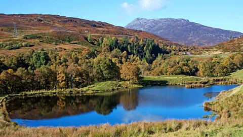
Schiehallion, in Perthshire, is what's often referred to as a whaleback ridge. The mountain runs from east to west – the north and south slopes are extremely steep – with a tricky, precipitous west slope marking the head, and a much longer, gentler eastern slope marking the tail, up which most hikes are attempted.
When I got my first glimpse of the head-end of Schiehallion from the northern shores of Loch Rannoch, I realised that it could almost for a volcano, with its steep sides tapering upwards to a sharp point. This was exactly the kind of mountain requested by Maskelyne in 1772 when setting fellow astronomer Charles Mason about the task of finding something of suitable bulk to survey.
Mason also needed to measure the mountain's volume and predict its mean density based on the type of rock of which it was composed. From these figures, Maskelyne would then be able to calculate the mountain's mass. In turn, he could scale these finding up to ascertain the Earth's mass to an acceptable degree of accuracy, using the Earth's radius to calculate its volume and making the best educated guess of our planet's density possible at the time. Knowing the Earth's mass would allow scientists to predict the relative masses of every known object in the known Universe, such as the Sun.
Mason travelled extensively, eventually finding the 1,083m-high Schiehallion with the expert help of local ghillie outdoor guides. Although a distinguished surveyor, who had recently returned to Britain after settling an aristocratic land dispute in the United States by establishing the Mason-Dixon line (later co-opted as a line of division in the Civil War), the idea of spending more months in the Scottish Highlands did not appeal to him.
 Julie Fryer Images/Alamy
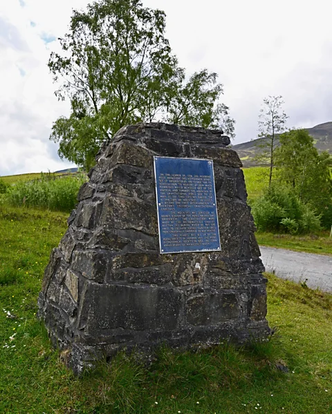
Maskelyne thus elected to personally oversee the work that would eventually give Schiehallion something akin to celebrity status in the hiking world, as evidenced by the 20,000 hikers who visit each year. They each a commemorative cairn, celebrating the work of Maskelyne and his team, in the Braes of Foss carpark at the start of the hike.
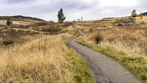
Not long into my own ascent of Schiehallion, I saw my first fellow hiker trudging down a well-trodden path, looking somewhat dishevelled. Early autumn had rebranded the bracken-laced slopes in a burnt sienna, while above me there was only cloud and, presumably, the rest of the mountain. Already though, with no large mountains nearby, the view from the lower slopes exposed vast tracts of central Scotland.
As the hiker neared me, I recognised an eager exhaustion in him. "I did it," he said. "My first Munro," referencing the 282 mountains across Scotland whose peaks lie above 3,000ft. With the carpark in sight, he was eager to get off the mountain. "I'm glad it's over," he said. His shellshocked-looking springer spaniel followed after him, barely stopping to sniff my boot.
You may also be interested in:
• An ancient Roman mystery solved
Gravity never seems quite as strong as when you're hiking uphill. In only a few minutes, I felt that sweet pull of the mountain drawing me in. Before long, the ground in front of me was all I saw; a morass of stone and hardy grasses, leading me on until we fell together like weary heavyweight boxers whenever I stopped for a water break.
Sir Isaac Newton was the first to determine that everything has its own gravitational force. He also believed that gravity was too weak to measure at anything lower than a planetary level. But without having a measurement of Earth's gravity, it would be impossible to calculate its weight, because gravity is variable. For example, if I stood on a bathroom scale on Earth, I'd weigh more than on the same set of scales on Mercury, a smaller planet than Earth with a lower gravitational force, even though my mass would remain the same.
What Maskelyne and other scientists of his time had realised was that if you could get close enough to its centre of mass, a mountain's gravity might be actually strong enough to measure. That meant finding a mountain with steep slopes. But if one mountain has a gravitational pull, so do all the others, potentially distorting the measurements. For this reason, Schiehallion, which was located far from other similarly sized mountains, was the perfect fit.
 Stan Pritchard/Alamy
Maskelyne requested that observation stations be built on Schiehallion's steep north and south slopes, at points closest to the mountain's centre of mass. From here, a pendulum was hung, pulled towards the centre of the Earth by our planet's own, superior gravitational force. Crucially, Maskelyne needed to prove that Schiehallion's gravity was drawing the bob of the pendulum away from its vertical position.
Maskelyne did this by tracking the transit of 43 different stars from each observation station to triangulate what is known as "true vertical", ie, the angle of the pendulum, had it been suspended on a flat plain, affected only by the Earth's gravitational pull and nothing else. He discovered that from each observation station on either side of the mountain, there was a clear deviation of the pendulum away from true vertical, towards the mountain.
Schiehallion's gravitational pull was thus proven, but the work was just getting started. Next, the whole mountain was to be surveyed in order to calculate its volume, a task that fell to the team of mathematician Charles Hutton.
Inclement weather is certainly no stranger to Schiehallion; it took Hutton's team almost two years to fully map the mountain because of it. As I reached the ridgetop, the clouds descended further, blotting everything out. Soon, the well-marked path disappeared into a challenging boulder field. Only the odd mist-obscured cairn indicated the way.
A spectral couple appeared through the gloom and told me that the peak was not too far off. Ten minutes later, the route I was on seemed to be heading downhill. But worse, the cairns had disappeared and the path was angling round towards the sheer north face. I found it difficult to tell whether the boulder I stood on was overhanging the abyss or just more stone, so I stopped to pull out my map and com.
When Hutton finished surveying the mountain, he had a map covered in thousands of precise longitudinal and elevation readings. In school we learn to compute a cube's volume by multiplying its length, width and height. But real life doesn't give us straight lines; it gives us curves, aberrations, knolls and fissures. These were exactly what Hutton's measurements showed.
 Paul Stafford
They were proving a little tricker to compute, and calculating the volume of the whole mountain seemed virtually impossible. Then Hutton had the ingenious idea of dividing the mountain up by bunching values at similar altitudes together. Taking a pencil, he connected those altitude points together, forming a series of imperfect rings. Inadvertently, he had just invented contour lines, which, to this day, remain one of the most valuable pieces of information on a map.
As I suspected, I was lost. After the correct path descended slightly from one of Schiehallion's many false peaks, I'd taken a wrong turn. My map showed densely packed contour lines right about where I judged myself to be standing, which meant it was about to get very steep, very soon. I abruptly retraced my steps, thanking Hutton and his contour lines for quite possibly saving me from falling over a cliff edge.
In 1775, Maskelyne presented the final results to the Royal Society. We now know that the estimations of Maskelyne and his team were within 20% of what the Earth is now thought to have a mass of (5.97 x 10^24kg, in case you were wondering), a significant improvement on previous estimates at the time. Maskelyne and Hutton's measurements were used as recently as 2007 to obtain a closer estimate of the Earth's mass.
Scientific discovery is not unlike hiking up a cold, damp, cloudy mountainside. But this 18th-Century feat cleared a great deal of mist for future astronomers and physicists, not to mention the many hikers who attempt to reach the peak of Schiehallion every day in homage to this geological marvel's contribution to our understanding of the cosmos. And thanks to those experiments, those ingenious contour lines will always give us a sense of a mountain's shape, even when our eyes cannot.
Geological Marvels is a BBC Travel series that uncovers the fascinating stories behind natural phenomena and reveals their broader importance to our planet.
--
more than three million BBC Travel fans by liking us on Facebook, or follow us on Twitter and Instagram.
If you liked this story, sign up for the weekly bbc.com features newsletter called "The Essential List". A handpicked selection of stories from BBC Future, Culture, Worklife and Travel, delivered to your inbox every Friday.
{"image":{"pid":""}}